Stage 1 Brief
MAHARASHTRA NATURE PARK
The Vision
The Maharashtra Nature Park Makeover on the south bank of the Mithi River, has an ambitious objective of inspiring an entire generation of Mumbaikars to respect and embrace nature and move towards greater sustainability through education, awareness and lifestyle choices.
The MNP Makeover has several interconnected and interdependent challenges that will require a multidisciplinary approach to strike the perfect balance between afforestation and complementary infrastructure. The forest-like environment is clearly the single most important asset of the park that has been nurtured over two decades. Its preservation and significant enlargement must be integral to any makeover. The supporting facilities today, however, are suboptimal and the city has lost a great opportunity to spread environmental awareness, as a result. The makeover must consider the spatial arrangements of existing functions and arrive at an ideal-case scenario for the proposed makeover with an objective to significantly enhance the nature education and nature tourism potential of the park. An intelligent spatial arrangement will play a key role in the success of any design.
About the Maharashtra Nature Park:
The transformation process of the municipal garbage dump began in the late 1970s, with efforts of the MMRDA and World Wildlife Fund – India, along with strong support from like-minded citizens, including Dr Salim Ali, the 'Birdman of India'. The 15-feet-high dump was painstakingly cleared. Fresh soil was spread over the entire area by volunteers and workers. Saplings were then planted on the new patch of land. MNP took 12 years to complete and was opened to the public in 1994. Over the years, the forest-like environment has grown and covered the landscape providing a real forest in the midst of an urban jungle.
The brick paths of MNP lead visitors to a forest-like setting that boasts of about 76 varieties of butterflies, more than 125 species of birds, and as many as 14,000 plants of 300 varieties, including at least 100 kinds of woody trees and a wealth of herbs and shrubs. Apart from these, MNP is a natural habitat for a wide range of insects, spiders, reptiles and amphibians. The forested area of the park occupies 17 acres with a nature trail called the Shanti Path (peace path) meandering through the trees. The path is approximately 4-feet-wide and 1.8-km-long and takes about an hour to complete at a leisurely pace. The nature trail acts as an excellent, up, close and personal introduction to Mother Nature. A freshwater reservoir at MNP occupies one acre and addresses the park's irrigation needs. It serves as an excellent backdrop for attracting birds and has set an example for water conservation through rainwater harvesting.
The park has an education centre shaped like the sun that comprises of an amphitheatre, audio-visual room, exhibition room, library, administration offices, and toilets. This building has 14,000 ft2 of usable space and has come to be loved by regular patrons despite its suboptimal use. Other than the forest ecology in MNP, the neighbouring 500 acres of mangroves and mudflats of the Mahim Estuary contribute significantly to the wealth of the area's biodiversity. The park includes a four-acre nursery on its western edge.
Challenges faced by the MNP:
The World Wildlife Fund-India had expected over 3,00,000 visitors to the MNP each year. The number of annual visitors to the park in 1994, when it was opened for general public, was 5,000. While this number has grown over the past two decades, the visitor count remains at about 100 individuals a day on average. A vast majority of these numbers are made up by school children, who are brought here as part of planned excursions. Such a low footfall is unacceptable for a city of 20 million.
Of the 37 acres on which the park stands, 13 acres on the eastern side are currently unused and have become grounds for open defecation and soft encroachments. The nursery on the western edge has similar issues of encroachment. It currently occupies four acres without contributing in any manner to the park's income or upkeep. It abruptly breaks the forest-like environment giving way to potted plants without adding any meaningful and significant value to the overall experience. The education centre, amphitheatre, and adjacent event ground located at the widest part of the park and occupy over three acres carved out of the forest-like core zone. This all-important asset – the forest-like zone is only 17 acres, occupying under 45% of the park's total area. Its walking trail, 'Shanti Path,' has become slippery and unsafe over time. All boundaries and fences of the MNP are in a poor condition and have been breached at multiple points along its perimeter.
The sun-inspired education centre of the park is visibly ageing and multiple annual structural audits by the MMRDA have confirmed that it is indeed in a poor condition and needs to be razed.
The Mithi River that runs along the northern boundary of MNP is one of the most polluted rivers in India. This northern boundary is 1.2 km long and there exists a natural walk-way along its entire length. This area this is two acres in size, could otherwise have been used as a waterfront promenade, is today heavily used for open defecation throughout the day. The pollutants in the Mithi's waters include raw sewage and municipal solid waste. It also carries oils and greases, heavy metals and other pollutants from effluents of unauthorised industries, all of which, are dangerous for the Mithi's fragile ecosystem. The foul appearance and odour of the Mithi River greatly affect the visitor experience at MNP. The MNP, however, is an integral part of the Mithi's riverbank. Its makeover must blend in smoothly with the future vision of an unpolluted Mithi with accessible and unbroken river banks along its entire length.
MNP is bordered by the informal settlement of Dharavi on the western and eastern side. Inadequate sanitation facilities on both sides have resulted in rampant open defecation which greatly reduces MNP’s appeal. Open defecation is above all is a matter of human dignity and its total abolishment is a national priority under the Swachh Bharat Abhiyan championed by Shri. Narendra Modi, Honourable Prime Minister of India. The park is also prone to trespassing and thefts of plants, saplings, gardening tools, wood and fruits. Poor waste collection services and on both sides of the park has resulted in large mounds of accumulated garbage on both sides of the park. These informal settlements make up an important stakeholder group and any makeover must be sensitive to their needs and priorities and aspirations.
All the current offerings that complement the forest-like core need to be reimagined along with the necessary built infrastructure to support it. The existing education centre, while inspiring in design, is able to cater to relatively smaller audiences. The new knowledge centre will need to cater to much bigger and more diverse crowds. Its range of activities too will have to be broadened and upgraded. Its design must be nature-inspired, remarkable and awe-inspiring both visually and experientially.
The experience of crossing the pedestrian and cyclist-only bridge must be a unique and unforgettable one. The successful design will have to meet stringent technical and construction criteria while keeping in mind the needs of those using the bridge.
The key demands for Stage 1 of the competition are:
- The 17-acre forest-like core should be preserved and significantly enlarged.
- Plans must take into account that the after the makeover, the park will cater to much larger number of visitors which must not disturb the ecological balance and carrying capacity of the MNP.
- Nature-inspired designs for the proposed knowledge centre and other built infrastructure.
- Development of a low-impact waterfront promenade over the natural walkway between the MNP boundary and the Mithi River in keeping with the larger vision for an unbroken pedestrian corridor along the entire river front.
- Minimise impact on the river, estuary, mangroves, the Maharashtra Nature Park itself, and other environmental assets in the vicinity.
- Factor in equal and balanced measure, the needs and aspirations of those living and working across both banks of the river.
- Affordable and practical solutions for operations, maintenance and support.
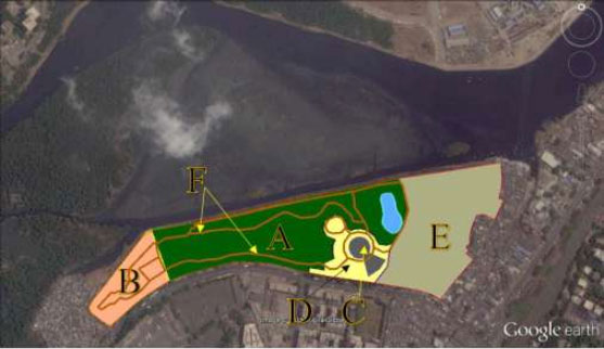
Existing layout of the Maharashtra Nature Park
| Zone/ Land use Today | Acres | |
|---|---|---|
| A. Core 'Forest-Like Zone' | 17 | |
| Non Forest Area within the active park area | B. Nursery | 4 |
| C. Round Building & Amphitheatre & Miscellaneous Structures | 1 | |
| D. Lawns, potted plants & tar road | 3 | |
| E. Unused/Barren/ Semi Barren space | 13 | |
| F. Internal park trail (1.8 km) | NA | |
| Total | 38 |
Area calculations using Google Earth
Stage 1 Brief
BKC to DHARAVI ~ MITHI RIVER BRIDGE
The Vision
The bridge is an integral part of the makeover of the Maharashtra Nature Park. It is seen as heralding a new wave of pedestrian-friendly and people-centric developments across the Mumbai Metropolitan Region. Equally important is the fact that it will span over 300-400 meters of the Mithi River – the most infamous water body of the city and the centre of focus during the deluge of 26 July, 2005. Creating a thing of beauty over one of the most polluted rivers in the country is a clear indicator of the strong intent and resolve to clean and restore the Mithi River for future generations to enjoy. The bridge will also serve as an important feeder to the MNP.
The 18 km-long Mithi River runs through some of the busiest and most densely-populated parts of Mumbai city. It flows through the largest informal settlement, hugs the most expensive and desirable real estate and touches everything in between. Most bridges that span the Mithi River and its tributary the Vakola Nala today, are bereft of any sense of aesthetics and design. Some are in a state of disrepair and most offer very poor quality of commute for pedestrians and cyclists.
River bridges often link neighbourhoods with different characteristics. This bridge will link the new national financial centre at BKC on the north bank of the Mithi with the most prominent informal settlement in Asia, Dharavi, on the river's south bank. How to create this bridge that is not only attractive, but also offers a 24/7 safe connection for pedestrians and cyclists is an important part of the assignment.
About Bandra Kurla Complex:
Bandra-Kurla Complex (BKC) is the new financial centre in Mumbai having recently supplanted Nariman Point. It is already providing more than two lakh jobs and is a poised to absorb future growth of offices and commercial activities. The complex has showcased tremendous growth in recent times. The BKC boasts of several corporate headquarters of MNCs. The complex has staff quarters, clubs, 5 star hotels, multiple convention centres and event venues, a diamond bourse, multi-speciality hospitals and a multitude of other offices.
The BKC covers an area of 370 hectares of once low-lying marshland reclaimed from the Mithi River and either side of its tributary, the Vakola Nala, as well as parts of the Mahim Estuary. This reclamation in the 1980s lead to the channelization of six km of the Mithi River in its estuarine reach from Mahim Causeway to CST Road Bridge. The BKC also hosts 30 km cycle track network which has been poorly used so far. The new bridge will also look to reactivate and revitalize this unique cycling infrastructure in the city by connecting it directly to areas like Dharavi, Sion and Chunnabhatti. Other ambitions are to create attractive pedestrian networks that connect to world-class walkways along the riverfront and to important public transport nodes.
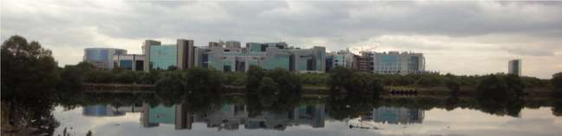
Reflections of the glass-facade buildings of the Bandra Kurla Complex in the Mithi River as seen from MNP's northern end.
About Dharavi:
Spread over 217 hectares, Dharavi is an important neighbourhood in Mumbai that houses one of the largest informal settlements in the world. Founded in 1880s during British Rule, its population grew exponentially with the growth of Mumbai as an industrial centre and mega port. Serving as a de facto home for rural poor migrating to Mumbai (then called Bombay), Dharavi is a multi-religious, multi-ethnic, diverse settlement that is the melting pot of all melting pots with densities as high as 18,000 people per acre. Dharavi's total population estimates vary between 3,00,000 to about 10,00,000.
Dharavi has a bustling informal economy where several residents find employment in home-enterprises. Goods are exported across the globe. Leather, pottery and textiles are the primary goods manufactured inside Dharavi. The total annual turnover is estimated at over Rs 3,000 Crores.
Dharavi has severe problems with public health, due to the scarcity of toilet facilities, due in turn to the fact that most housing and majority of the commercial units in Dharavi are illegal. The lack of access to sanitation and waste management infrastructure forces residents into the environs of the Mithi River and Maharashtra Nature Park for unchecked open defecation and garbage dumping. This has led to the spread diseases. The area also suffers from problems with inadequate water supply.
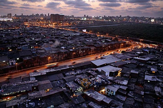
Dharavi by night with mangroves in the background
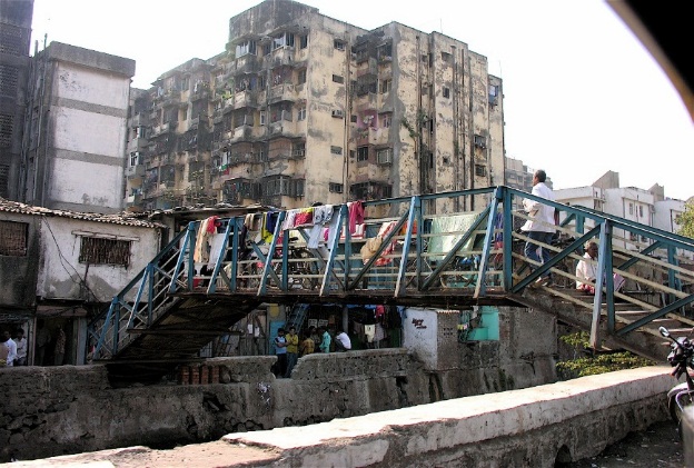
Inside Dharavi
The Mithi River Bridge must be a world-class construction with respect to designs, material choices and quality of work. It must be inspiring yet aesthetically pleasing and functional in its design.
The final alignment of the bridge may be over large mudflats in the estuarine reach of the Mithi River. This low-lying area is not suitable for boating or any regular water transport. Its landing points may be prone to flooding and this must be factored into its design.
The bridge will be directly visible from about 5 km of the Mithi's north and south banks. The glass façade sky scrapers of the BKC and the future buildings that will replace the informal settlement of Dharavi will all surround nearly 500 acres of Mithi River Estuary, with the bridge standing out as its centrepiece. The design must factor how the bridge will appear from a distance as well as from different perspectives. Since it is expected to be used throughout the day and well after sundown, the night-view of the bridge is also important.
The experience of crossing this bridge must be a unique and unforgettable one. The successful design will have to meet stringent technical and construction criteria while keeping in mind the needs of those using the bridge.
The key demands for the bridge in Stage 1 of the competition are:
- Seamlessly connecting the bridge to the Sion-Dharavi Link Road, taking pedestrians and cyclists towards Sion and Chunnabhatti Stations on the Suburban Railway Network.
- An iconic and unique design with a low environmental footprint.
- An appropriate design for an estuarine environment where the mudflats get exposed and covered twice a day with changing tides.
- Intelligent segregation of park users and bridge users and while serving as a feeder for MNP.
- It should embody the famed spirit of Mumbai, while creating an inspirational link between two very unique parts of the city that are economically, socially and environmentally very different from each other.
- The bridge must ensure a safe and stimulating experience for pedestrians and cyclists crossing the river.
- It must take into consideration the climate of Mumbai throughout the year.
- Its designs must actively encourage movement between the two banks of the river and be a torchbearer for walkable urbanity and disabled-friendly public infrastructure. It must encourage a shift from motorised modes of transport to walking and cycling.
- It must leverage the existing pedestrian and cyclist infrastructure across the BKC, where it lands.
- It must have minimum impact on the river, estuary, mangroves, Maharashtra Nature Park and other environmental assets in the vicinity.
- Factor in equal and balanced manner, the needs and aspirations of those living and working across both banks of the river.
- Low cost and practical solutions for operations, maintenance and support.
Transport case:
This pedestrian and cyclist-only bridge will be roughly 300-400 metres in length. It will seamlessly connect nearby transport hubs including several bus stops, major bus depots at Dharavi, Sion, Chunnabhatti, Bandra, and Government Colony (BKC) as well as important suburban railway stations and associated skywalks of Bandra and Mahim on the Western line, Sion on the Central line and Chunnabhatti on the Harbour line. This seamless connectivity is also planned so as to include Bandra, MMRDA, and Income Tax and Bharat Nagar stations on the upcoming Line II of Phase 1 of the Mumbai Metro Project. This pedestrian infrastructure must encourage walking and save time while simultaneously decongesting vehicular traffic, becoming a landmark and a connector of destinations at the same time. This component is strongly aligned to the Smart Cities vision of Shri. Narendra Modi, Honourable Prime Minister of India
Upcoming BKC-Chunnabhatti Connector:
The location and alignment of the proposed pedestrian-and-cyclist-only bridge will have to consider the alignment upcoming BKC-Chunnabhatti Connector which has been finalised and approved. Work on the 1.6 km long connector has already commenced.
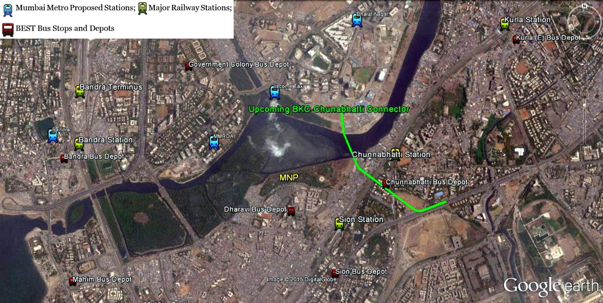
Consolidated Connectivity Map showing present and future transport hubs and infrastructure
At Stage 2 of the competition, the shortlisted competitors will be asked to develop their design ideas for a more precise alignment of the bridge in consultation with Jury Members and the MMRDA.
Whilst all the information in the website is believed to be correct at the time of issue, neither MMRDA nor ORF Mumbai make any warranty or representation (expressed or implied), with respect to such information; nor will they accept any liability for its accuracy, adequacy or completeness.